Last weekend I purchased a small booklet entitled "Windmills of Sussex" at a car boot sale. This work was an expanded version of "Seven Sussex Windmills" which was probably published sometime in the 1970's. If you like second hand books, car boot sales can represent the high and low points of book hunting. There are two rules, first, the probability of finding something interesting is inversely proportional to the distance travelled and secondly, If you like a book, buy it then and there because it won't be there next week.
Windmills are interesting because they are sited at locations for which there is no obvious source of wind speed data other than the mill itself, so how did millwrights and owners decide where to build. In the 19th century there was a substantial number of millwrights equivalent to the wind turbine industry of today and part of their expertise must have been a knowledge of wind and terrain. Whilst there are descriptions of wooden post mills being dragged from one location to another by teams of oxen which suggests that if a location proved to be unsuitable, there was a chance of moving on. However, the this was not possible with the large brick built structures that appeared on the latter half of the century, therefore getting it right first time was important.
When I first became interested in wind energy, it became clear that the variation in wind speed over a small area can be very large. In the coastal town where I live the wind coming of the sea can be a smooth 10 m/s on the seafront, my backyard can be calm and the foothills gusty. The variation is due to terrain and surface texture.
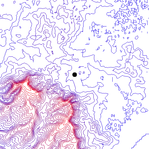
The SRTM dataset collected by the Space Shuttle in 2000 is a good tool for displaying terrain. I wrote a very basic programme to draw custom contour maps centered on a given location. These can also be used as overlays with Google Earth which provides some additional context. One, trivial exercise consisted of walking across the South Downs from the seaward side, over the crest and down the landward side with a wind speed meter and relating the results to reports from an airfield a few km to the west (This is described in a previous post).
The plots below are for the "Seven Sussex Windmills", the location of each being obtained from Wikipedia:
 |
| Argos Hill |
 |
| Clayton |
 |
| Nutley |
 |
| Polegate |
 |
| Shipley |
 |
| Punnett's Town |
 |
| West Blatchington |
With the possible exception of the Polegate mill, all are located on hills, ridges or open ground. A similar exercise with wind farms produced similar results. What I would like to know more about is seasonality of milling with wind. At a guess, its seasonal peaking around August and September after the harvest has been gathered in. If it is seasonal, the location of the mill would be influenced by the prevailing wind after the harvest.
References
Windmills of Sussex, Brian Austen, Sabre Publishing 1978
SRTM - Wikipedia
Windmills in East Sussex (Wikipedia)
Windmills in West Sussex
The wind, mobile phone and the Space Shuttle
References
Windmills of Sussex, Brian Austen, Sabre Publishing 1978
SRTM - Wikipedia
Windmills in East Sussex (Wikipedia)
Windmills in West Sussex
The wind, mobile phone and the Space Shuttle


No comments:
Post a Comment