You can learn a lot about solar irradiance from one's own backyard, but studying the wind means leaving the house. From watching lost toy balloons, hot air balloons that I hope were not lost, walking and cycling around the town and countryside with a wind speed meter and looking at data from personal weather stations, I have formed the hypothesis that wind flows reasonably steadily of over hills and humps but is attenuated and gusty in the dips in between. If wind blows up a valley, there can be a funnelling effect in which case the valley ceases to be a place of shelter. In other words wind does not always flow parallel to the surface. As always, these comments should be treated with caution as other conclusions maybe possible with wider experience and greater knowledge.

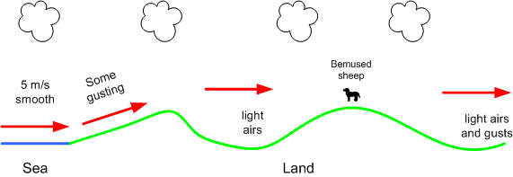
On 21-Sep-2013, I walked along a ridge from which there was a sea view, then dipped into a valley, as I walked along the path that lead to the next ridge I encountered a bemused sheep which continued to graze whilst I messed with a wind speed meter. Beyond this second ridge is an inland plain. On the seafront, the wind was blowing steadily at 5 m/s from the south west. The sketch below is an interpretation of the wind speed measurements I took along the way. On the slope up from the sea the wind blew steadily with some gusting as it did on the two ridge tops. In the valley, the air was still, with little movement in the tree tops. On the plain, there were some light gusts of wind. The red arrows suggest the path of the wind.
I recently wrote a small programme to draw contour lines using SRTM data. Whilst this was written for some other purpose, I have used it to plot the terrain around a random selection of windmills (the sample size was 14) identified from Wikipedia. A little reading around the subject suggested that location of many mills is named "Mill Hill" (obvious with hindsight). If you Google "Mill Hill" you wind find a diverse list of places around the UK. Not all windmills are located on ridges and hills, but it is a favoured location. The graphic below shows a typical windmill location in a hilly region, the red contours are the high ground and the blue ones are the surrounding low lying area.

One source of wind data is aviation weather reports (Metars). It was whilst looking at the terrain on which airfields were located, it appeared that some which were laid out in the 1920's and 1930's are located on plateaus, like the one shown below. This observation is from a very small sample but may have some logic. A favourable wind would help getting a heavily laden and by today's standards, under powered aircraft off the ground

And my point is? The number of onshore locations where a wind turbine can be usefully be placed is constrained by terrain. This is further influenced by accessibility (almost everywhere belongs to someone) and acceptable land use.

No comments:
Post a Comment